One of the most economically, culturally and strategically important regions of Bangladesh Khulna division is the Jessore district, where the Upazila Sharsha is located. Sharsha, which is located adjacent to the Indian state of West Bengal, is one of the most important land borders of Bangladesh with its neighboring country, as it supports trade and connectivity.
Table of Contents
ToggleGeography and Location
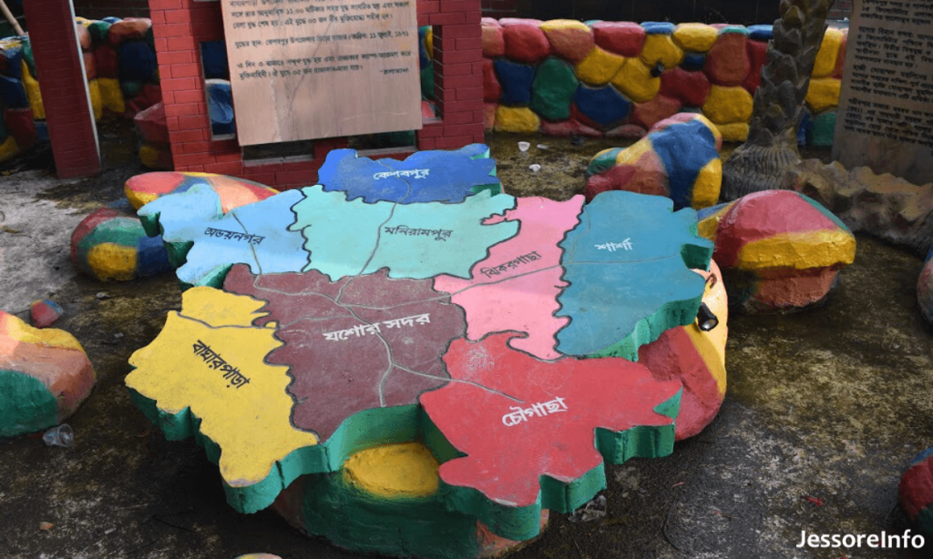
Geographically, Sharsha Upazila lies between 22°55′ and 23°12′ north latitudes and 88°51′ and 89°01′ east longitudes, covering an area of approximately 336.28 square kilometers. The area is bordered by Bagdah CD Block in North 24 Parganas district in West Bengal, India, to the north, Chowgacha Upazila to the north, Jhikargacha Upazila to the east, Kalaroa Upazila of Satkhira District to south and Bangaon and Gaighata CD Blocks in North 24 Parganas district in West Bengal, India, to the west.
Population and Demographics
According to the 2022 census, the population of Taluk of Sharsha Upazila is 387631. Islam is the most widely practiced faith, while Christians, Buddhists, and several Hindu minorities also exist. With a literacy rate of about 48.29%, Chhattisgarh has a lower average than the nationwide average.
Administrative Structure
Sharsha Upazila consists of one municipality and 11 union parishads, which will be added to the map as layers and analyzed separately. Benapole is a municipality that is also divided into 9 wards and 12 mahallas. Sharsha, Bagachra, Bahadurpur, Benapole, Dihi, Goga, Kayba, Lakshmanpur, Nizampur, Putkhali and Ulashi union parishads They are further divided into 135 mauzas and 168 mouzas.
Economic Significance
1. Benapole Land Port
Benapole Land Port, the largest land port of Bangladesh, is one of the most notable complexes of Sharsha Upazila. Located in Benapole town, this port is the largest port in Bangladesh-India trading, and accommodates a large proportion of the total import and export of the country.
2. Agriculture
Just like other parts of the world, agriculture is the main economic activity in Sharsha, so the inhabitants also work in agriculture. This land is highly suitable for the cultivation of rice, jute, sugarcane and vegetables. It is especially known for banana plantations and date molasses.
Building Blocks for Development and Infrastructure
There have been many development projects to improve infrastructure and public services in Sharsha Upazila. This includes the construction and reconstruction of rural roads, bridges, and culverts, as well as the development of rural markets and communication facilities.
Transport and Connectivity
There are many roads in the upazila and the Jessore-Benapole highway is like a big highway in the upazila. Buses and auto rickshaws are available for public and private transit from this area and the surrounding areas.
Cultural and Social Aspects
Sharsha Upazila has a large mixed population with diversified cultural bases. The coexistence is also demonstrated by several religious and cultural festivals celebrated throughout the year. Its closeness to the border also plays its part in the regional cultural traditions with cross-border interactions contributing to a unique blend of traditions.
Sharsha Upazila is one of the prominent locations, a commercial and culturally rich area of Bangladesh. Bordering 10 feet high, 38 km long and 60-meter wide fencing wall in the south and west of the district, it is fulfilling its part of the duty in development to a great extent being one of the entry points for international trade through Benapole land port which is making Sharsha a great contributor to national stage.