Jhikargacha Upazila is one of the eight upazilas of Jashore District in Bangladesh’s Khulna Division. It includes Jhikargacha Municipality and 11 union parishads and is particularly known for the commercial flower-growing areas of Godkhali and Panisara.
According to the 2022 Population and Housing Census, Jhikargacha Upazila had a population of 331,123 and a literacy rate of 76.35% among residents aged seven years and above.
Jhikargacha Upazila at a Glance
| Official name | Jhikargacha Upazila |
|---|---|
| Common English spellings | Jhikargacha and Jhikargachha |
| District | Jashore |
| Division | Khulna |
| Approximate area | 308.09 square kilometres |
| Population | 331,123 in the 2022 census |
| General households | 88,106 in the 2022 census |
| Literacy rate | 76.35% among residents aged seven years and above |
| Municipality | Jhikargacha Municipality |
| Union parishads | 11 |
| Main postal code | 7420 |
| Important river | Kopotakkho River |
| Known for | Godkhali and Panisara flower cultivation |
Where Is Jhikargacha?
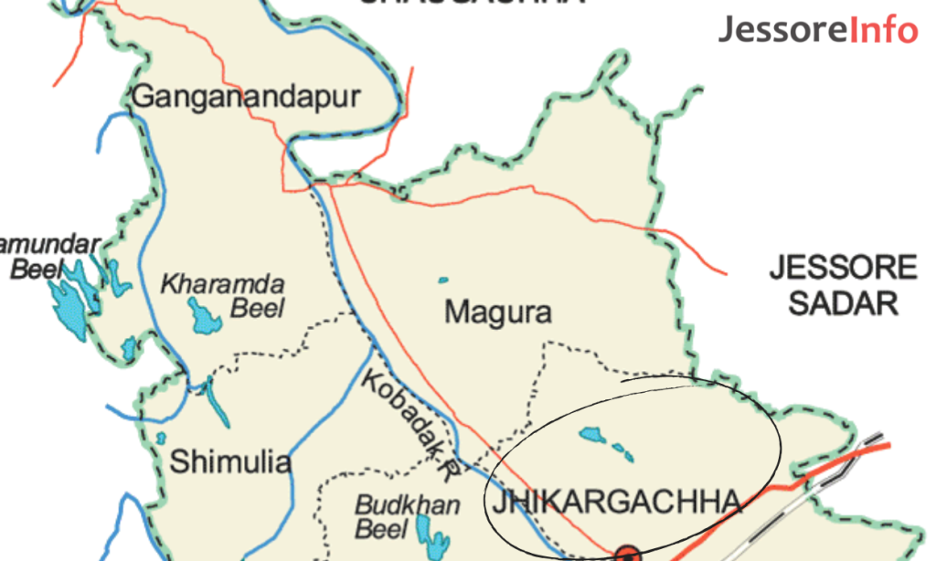
Jhikargacha is located in the western part of Jashore District. According to the official upazila profile, it is bordered by:
- North: Chaugachha Upazila
- East: Manirampur Upazila
- West: Sharsha Upazila
- South: Kalaroa Upazila of Satkhira District
Jhikargacha town and the Upazila Parishad are beside the Jashore–Benapole highway. The official local-government route information places Jhikargacha Upazila Parishad approximately 13 kilometres from Jashore and approximately 23 kilometres from Benapole.
Distances should be treated as approximate because the actual journey depends on the traveller’s starting point and current road conditions.
View Jhikargacha Upazila Parishad on Google Maps.
Population and Literacy
The Bangladesh Bureau of Statistics recorded the following figures for Jhikargacha Upazila in the 2022 Population and Housing Census:
| Indicator | 2022 census figure |
|---|---|
| Total population | 331,123 |
| Male population | 159,614 |
| Female population | 171,509 |
| General households | 88,106 |
| Average general household size | 3.73 |
| Literacy rate, age seven and above | 76.35% |
These figures cover the entire upazila, including its rural and urban areas. They should not be presented as the population of Jhikargacha town alone.
Jhikargacha Municipality
Jhikargacha Municipality had a population of 37,029 in the 2022 census. It contained 9,723 general households and recorded a literacy rate of 83.24% among residents aged seven years and above.
The municipality has nine wards. The older article’s statement that it has six wards is incorrect.
Union Parishads of Jhikargacha
Jhikargacha Upazila consists of one municipality and the following 11 union parishads:
- Bankra Union
- Gadkhali Union
- Ganganandapur Union
- Hajirbag Union
- Jhikargacha Union
- Magura Union
- Nabharan Union
- Nirbaskhola Union
- Panisara Union
- Shankarpur Union
- Shimulia Union
Spellings may vary between English-language government documents. For official applications, land records or certificates, use the spelling shown by the relevant government office.
Jhikargacha Postal Code
Bangladesh Post lists the main Jhikargacha UPO postal code as:
| Post office | Upazila | District | Postal code |
|---|---|---|---|
| Jhikargacha UPO | Jhikargacha | Jashore | 7420 |
A complete address should also include the village, union, upazila and district. Confirm the responsible delivery office when sending an item to a remote village, as not every locality is necessarily served directly from the main UPO.
For other areas, see the Jashore postal code guide.
What Is Jhikargacha Famous For?
Jhikargacha is best known outside the local area for commercial flower cultivation, especially around Godkhali and Panisara. It is also an agricultural upazila with markets, educational institutions, waterways and road connections towards Jashore and Benapole.
Godkhali and Panisara Flower Area
Commercial flower cultivation has developed across parts of Godkhali and Panisara. Visitors commonly travel to the area during the cooler season when flower production is visually abundant, but the appearance of individual fields depends on planting, harvesting and weather.
Godkhali is not a single enclosed flower park. Most flower fields are working agricultural land and may be privately owned or leased. Visitors should ask permission before entering, avoid stepping on crops and never pick flowers without purchasing them or receiving the grower’s consent.
View Godkhali Flower Market on Google Maps.
For detailed travel guidance, see the Godkhali travel guide.
Kopotakkho River
Jhikargacha Bazar is located beside the Kopotakkho River. The river is an important geographic and cultural feature of the area.
Visitors should not assume that boating, swimming or unrestricted riverbank access is available. Water depth, current, pollution levels and bank conditions can change. Use only authorised boats, follow local safety advice and supervise children near the water.
View the Kopotakkho River area on Google Maps.
Betna River Area
The government tourism directory also identifies the Betna River near Ulashi in Nirbaskhola Union as a local place of interest. It is better treated as a rural landscape and waterways destination than as a developed tourist facility.
Economy and Agriculture
Agriculture, local trade, transport and small businesses are important parts of Jhikargacha’s economy. Crops and products vary by union and season.
Flower cultivation is especially visible in Godkhali and Panisara, where growers, traders, transport workers and local markets form part of the flower supply chain. However, claims about exact production volume, market share or annual financial value should be supported by a recent government or industry report.
The upazila also contains ponds, baors, rivers, canals and fish markets. Current fisheries statistics should be taken from the local Department of Fisheries rather than copied from older profiles.
Education and Public Services
Jhikargacha has primary and secondary schools, colleges, madrasas, government offices and local service centres across the municipality and union parishads.
Residents seeking government services can begin with the official Jhikargacha Upazila portal. It provides access to local-government departments, staff directories, notices and service information.
For a specific school or college, verify admission information through the institution’s official website, the Jashore Education Board or the responsible education authority. Old establishment dates and institution lists should not be copied without confirmation.
Healthcare and Emergencies
Jhikargacha Upazila Health Complex is the main government health facility serving the upazila. Available doctors, departments and contact numbers can change, so patients should verify current information through the official health-office portal.
For emergencies in Bangladesh:
- National emergency service: 999
- Government information and services: 333
- Fire service: 102
Do not delay urgent treatment while attempting to confirm routine directory information online.
How to Go to Jhikargacha
From Jashore city
Travel west from Jashore on the Jashore–Benapole highway. The official upazila information places Jhikargacha Upazila Parishad approximately 13 kilometres from Jashore.
Local and regional buses operate along the corridor. Depending on the starting point, travellers may also use a reserved car, microbus, CNG-powered vehicle or other local transport. Ask whether the vehicle stops at Jhikargacha Bazar, Thana Mor or Upazila Parishad.
From Benapole
Travel east towards Jashore on the Benapole–Jashore highway. Government route guidance places Jhikargacha Upazila headquarters approximately 23 kilometres from Benapole.
Confirm the stopping point before boarding because some long-distance buses may not stop at every local market.
Travelling to Godkhali
From Jashore, use the Benapole-bound road and get off at Godkhali. For specific flower fields, visitors may need a local easy-bike, van or reserved vehicle from the market area.
Ask a local grower or trader which fields are active before entering agricultural land.
Suggested Day-Trip Plan
A practical day trip from Jashore may include:
- Travel towards Jhikargacha on the Jashore–Benapole highway.
- Visit Godkhali Flower Market early in the day.
- Enter a flower field only after receiving permission.
- Continue to Jhikargacha Bazar and view the Kopotakkho River from a safe public area.
- Return to Jashore before evening or continue towards Benapole if that is part of the itinerary.
Flower availability, road traffic and local access can change. Confirm conditions shortly before travelling.
Practical Information for Visitors
- Use both “Jhikargacha” and “Jhikargachha” when searching online.
- The main Jhikargacha postal code is 7420.
- Use the official Upazila portal for current administrative information.
- Do not enter privately cultivated flower fields without permission.
- Avoid quoting old transport fares as current prices.
- Confirm the exact union and village for rural addresses.
- Check weather and road conditions during the monsoon.
- Keep waterways clean and avoid leaving plastic or food waste.
- Use 999 for an immediate national emergency.
Official Information Sources
- Jhikargacha Upazila official portal
- Population and Housing Census 2022: District Report, Jashore
- Bangladesh Post: Jashore postal codes
Frequently Asked Questions
Where is Jhikargacha Upazila?
Jhikargacha is in Jashore District of Khulna Division. Its Upazila Parishad is beside the Jashore–Benapole highway.
What is the population of Jhikargacha?
Jhikargacha Upazila had a population of 331,123 in the 2022 Population and Housing Census.
What is the literacy rate in Jhikargacha?
The 2022 census recorded a literacy rate of 76.35% among residents aged seven years and above.
How many unions are in Jhikargacha?
Jhikargacha Upazila has 11 union parishads and one municipality.
How many wards are in Jhikargacha Municipality?
Jhikargacha Municipality has nine wards.
What is the postal code of Jhikargacha?
The Bangladesh Post directory lists Jhikargacha UPO postal code as 7420.
What is Jhikargacha famous for?
It is particularly known for commercial flower cultivation around Godkhali and Panisara. The Kopotakkho River is another important feature of the area.
How far is Jhikargacha from Jashore?
The official local-government route page places Jhikargacha Upazila Parishad approximately 13 kilometres from Jashore. Actual distance depends on the starting point.
When is the best time to visit Godkhali?
The cooler part of the year is commonly preferred, but flower availability depends on crop and harvesting cycles. Check locally before travelling.